
I guess I am officially a highpointer now. I spent last weekend on an epic adventure that included over 900 miles on the road and three state highpoints: Spruce Knob in West Virginia, Hoye Crest in Maryland, and Mount Davis in Pennsylvania.
Logistically, it makes sense to do these three hikes on a single trip as they all sit along a ridgeline running up through West Virginia, western Maryland, and southwestern Pennsylvania. Since I was already in New Jersey with Gramps, I called up my Dad who lives in Maryland and is an avid geocacher. (Don’t know about geocaching? Check out everything you want to know here and get ready for a whole new adventure!) He said he’d love to take a mini road trip with me and so I was off.
I jumped on the I-95 south and headed through southern New Jersey, over the Del-Mem bridge, through the short stint of Delaware, through northern Maryland, under the Harbor in Baltimore, and out to Annapolis to meet up with my Dad. He had plans for dinner: crabs! After catching up for a bit we headed to bed early.
The next morning we woke up with the first light of morning and jumped into the car. Our first stop was Spruce Knob in West Virginia, but getting there was crazy. Out I-66 ’til we cut through rolling farmland to get over onto the I-81. Before long it was time to get off the highway and were heading up and down, up and down through the undulating waves of the mountain ridges going into West Virginia. The last bit of road up to Spruce Knob was a white-knuckle gravel road winding along the edge of a steep mountain edge. Dad and I hiked along the Huckleberry Trail taking in what seemed to be a magical, moss-covered forest. Then we spent a while inspecting the two separate USGS markers in the vicinity of the summit. We didn’t stay too long at the top because we were on a mission to hit up all three highpoints in one day!
As we drove north toward Hoye Crest we spotted what looked like a spine of rocks sticking out dramatically from the surrounding trees. Turns out we ended up driving right past Seneca Rocks! We stopped on the roadside to snap a few photos and continued on our way. About an hour further up the road and we drove right past the trailhead for the Maryland state highpoint. We turned around and located it on the left side of the road. The trail up to Hoye Crest is called Backbone Mountain Trail (Hoye Crest is the top section of the ridge-like Backbone Mountain). It is not a long trail, but it was the steepest I had encountered yet and was a muddy mess. But we trudged along and soon we came around a corner and ran smack into a huge stone marker. The Backbone Mountain Trail begins in West Virginia and most of the way up you are still hiking in West Virginia. Then you come around a curve and you hit the state line, complete with a more than 100-year-old granite obelisk marker. A hundred yards later and we were on the highest point of Maryland. There was a sign, a mailbox with a ledger to sign inside provided by the Highpointers Organization, and probably the biggest cairn I have ever seen.
Dad and I spent quite a bit of time on the summit, mostly because we could not find the USGS marker anywhere. We checked forums, blog posts, SummitPost, and even used Dad’s GPS to determine the exact highpoint but had no luck. Maybe it’s under that massive cairn, but we didn’t have enough time (or the heart) to dismantle the huge pile of rocks. After wandering around the summit for a while we headed back down the trail and back into West Virginia to get back on the road.
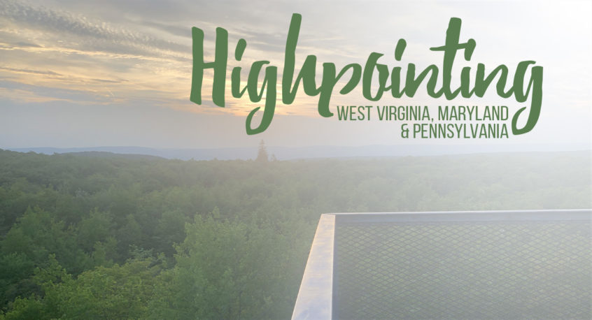
Heading north again we raced against the setting sun through Maryland and up into Pennsylvania. Suddenly we found ourselves in Amish country. Carriages road past us with older couples, young boys and young girls. We road through the farmlands up the long broad Mount Davis. We parked near the summit and rushed in towards the view tower. Climbing up I became acutely aware that I did not like the height and downward view through the stairs. Was highpointing going to work out for me? The view looking out over Pennsylvania totally made up for the slightly queasy feeling in my belly. After we had our fill of the views we head back down and were determined to find the USGS marker here. The guys from back home said they hadn’t been able to find one, but after a no-show on Maryland, we weren’t ready to give up quickly. Eventually, we <em><strong>did</strong></em> find the metal marker, but it was not easy to find and was in what I would call an “expected location.”
With the sun just below the horizon, Dad and I headed back into Maryland and jumped on I-70 heading east. Before we got too far Dad mentioned there was a restaurant in Cumberland that he knew with good food and great Amish pie. After a full day of driving and hiking, dinner and pie sounded amazing! We settled into a booth and finished off the evening with a hearty meal.
Then it was time for me to drop Dad off at home and head back to New Jersey. Two and a half days, 912 miles, and three highpoints later, I fell into bed just after 2 am. What a weekend!